
NASA's ATREX rocket launch will study ultra-high-altitude jet stream currents
NASA’s ATREX project is a multi-rocket launch that will study ultra-high-altitude jet stream currents. These aren’t the “jet streams” that we typically see on weather maps, but areas of high winds (up to 300 mph) that are 60 miles above the Earth’s surface. For a comparison, you can view this large illustration from NASA that shows the layers of the atmosphere, with weather-related jet streams at six miles (or 30,000 feet) and ultra-high jet streams being 10 times that high!
The experiment will send five rockets into that same altitude where the strong jet streams exist, and the rockets will release a chemical that glows white when exposed to oxygen and will allow scientists to view the paths that the jet streams follow as the white chemical is carried along by the high winds.
Here’s NASA’s description of the experiment:
The rockets will be launched on a clear night within a period of minutes, so the trails can all be seen at the same time. The trimethyl aluminum will then be released in space out over the Atlantic Ocean at altitudes from 50 to 90 miles. The cloud tracers will last for up to 20 minutes and will be visible in the mid-Atlantic region, and along the east coast of the United States from parts of South Carolina to New Jersey.
The video below also gives a good overview of the entire process:
Although the experiment has been postponed a few times due to unfavorable weather conditions, the launch is now set to take place on March 21st.
03.19.12 – NASA has scheduled the launch of five suborbital sounding rockets from the Wallops Facility in Virginia as part of a study of the upper level jet stream from midnight to 5 a.m. EDT, Wednesday, March 21.
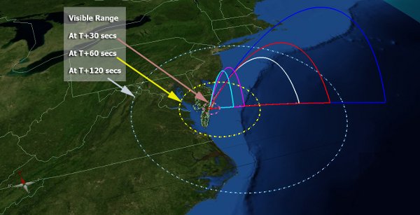
The image at the top of the page shows circles which may be able to see the white trails left by the rockets. I’m located in New York City, so there’s a small chance I’ll be able to see them, but if you are along the coastline near Virginia, be sure to check the eastern sky in the early hours of Wednesday for white trails, which will look like these trails from a similar experiment in Alaska in 2009.
[Update – 3/20] The launch of the rockets is delayed again due to weather:
The launch of five rockets has been officially rescheduled for Wed./Thurs. starting midnight- 3 a.m. go.nasa.gov/A3r7z2
— NASA (@NASA) March 21, 2012
Some good news, however, is that there is another viewing map that shows the maximum range for a possible viewing of the ATREX trails, and it shows NYC within the viewing area!
[Update – 3/21] The fog rolls in again! Dense fog in the northeast scrubbed the rocket launch once again:
We have scrubbed the launch window beginning at midnight on 3/22. Next attempt begins at midnight 3/23 and runs through 3 a.m. on 3/23.
—- NASA Wallops (@NASA_Wallops) March 22, 2012
The forecast for Thursday shows high temps and partly cloudy skies, so the chances for a successful launch may be better than the past few days, when nights were foggy.
[Update – 3/23] I admit, I had my alarm set for every hour or so last night, and I was waking up to check my phone and see if ATREX was about to launch. Unfortunately, 1:30am rolled around and once again it was a no-go!
Scrubbing mission for tonight. Weather and boats not wanting to cooperate tonight. Standby for next launch attempt.
—- NASA Wallops (@NASA_Wallops) March 23, 2012
Due to expected poor weather, the next launch attempt for the ATREX mission will be no earlier than Monday, March 26 from midnight- 3am.
—- NASA Wallops (@NASA_Wallops) March 23, 2012
[Update – 3/27] Success! I had to stay up all night to see the launch, but it was totally worth it! At 4:58am on Tuesday morning, the five rockets were launched from Wallops Island, VA and I saw four separate chemical trails from Manhattan!
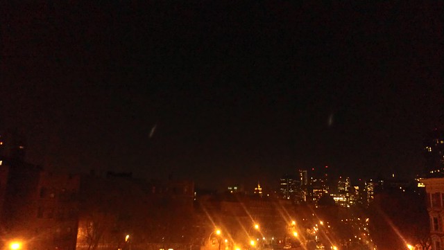
The first two chemical trails seen from Manhattan
As the rockets released the trimethyl aluminum, they made a large, bright smear against the early morning sky, and over about 20 minutes, the trail faded and was dispersed as it moved along with the high-altitude jet stream. The four trails I was able to see were within about 30° of each other from South to Southeast, and about 40° up from the horizon.